Most of us know about Bear Butte, a stand-alone monolith towering 1,200 feet above the prairie just east of Sturgis. But did you know it was originally formed 2,000 feet underground? On September 10 the Black Hills Explorers climbed high to get to the bottom of this mystery.
 |
| Photo (c) 2011 Lee Alley |
The Butte, called Mato Paha (“Bear Mountain”) by the Sioux Indians, is so named for its resemblance to a reclining bear in eternal sleep resulting from combat injuries. On this trip, the Explorers were joined by geology professor Alvis Lissenbee, who has studied the geology of the area extensively. Lissenbee explained that around 50 million years ago, this entire area was covered by a lake bed 2,000 feet above the current prairie. Then, Dr. Lissenbee explained, molten magma (quartz monzonite) from far below was thrust upward into higher underground cavities. That is the same extra-hard material of the boulders and needles around Mt. Rushmore. However, the magma that formed what is now Bear Butte chilled more quickly, resulting in its highly fragmented small pieces. Eventually the softer sandstone and shale over and around this mass has eroded, swept toward the Gulf of Mexico, leaving the Butte to stand 1,200 feet above its surroundings. We were also joined by one of the park rangers who helped us appreciate the long-held deeply spiritual place of Bear Butte in Lacota culture. There was an impressive display of items used in Lacota spiritual practices.
 |
| Like walking on tennis balls. |
On this adventure the Explorers were made uncomfortably aware of the small talus rocks that formed the Butte, as they rolled and slid under underfoot. The trip to the top was long, steep, hot, and sometimes precarious. If one goes, it should be noted that some of the stairs are difficult to manage, and some in need of repair. However, the reward for reaching the summit was a delightful 360-degree panorama of the entire Black Hills skyline, from Crow Peak west of Spearfish, to The Needles south of Harney Peak, plus the vastness of the surrounding prairie.
 |
Some of many steps along the way.
(Sorry, Google's Blogger insists on us hiking sideways!) |
On October 8 the Explorers will celebrate its first annual Fall Foliage Foto Tour, this year along the Horse Thief Lake Trail. The purpose of the Black Hills Explorers is to explore new knowledge, activities and places in the Black Hills in order to better appreciate where we live. The group normally meets the second Saturday of each month by 8:15AM at the Canyon Lake Center (but check each time, for occasional re-scheduling). Sign up at least two days prior, in the Canyon Lake Center office. Van seating is first-come/first-served for pre-signups. For questionable weather, check the web site prior to leaving.
More information about the Black Hills Explorers can be found at www.BlackHillsExplorers.org or by calling Lee Alley at 605.863.0806. Any person of any age is invited to accompany the Black Hills Explorers’ activities, and encouraged to join the Canyon Lake Center. Be sure to read the special Participation Guidelines for each trip when you sign up.
 |
What's in a name? The first to summit:
Kathleen, Kathy, Cathy and Kathryn.
Too bad my wife, Kathryn wasn't able to come. |
 |
Well, hey. Why not? Google's software won't allow this upright either!
This is Dr. Alvis Lissenbee describing how the Black Hills were formed sideways. |
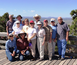 |
| The Black Hills Explorers |
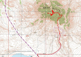 |
| Thanks, Clint, for this GPS track of our route. |


